

Best of the West day walks
QUIET TRAILS, AWESOME VIEWS, PHOTO STOPS
Goodbye crowds! Discover hidden gems, stunning landscapes, wide open spaces, tales of old.
One region. Two legs. Six of the best day walks. You'll need a moderate to good level of fitness for these awesome trails, a most rewarding way to experience the true heart of New Zealand’s West Coast.
NOTE: While walking, tramping and hiking is a year-round activity on the West Coast, you should always check weather and track conditions before setting out. Always take warm, waterproof clothing as the weather can change rapidly.


Ōpārara Valley Track
The Ōpārara Basin, north of Karamea, reveals magnificent limestone arches, luscious rainforests and caves full of secrets.
Go North: Ōpārara Valley Track, Karamea
5 hr / 14 km one way
Karamea — the West Coast’s best kept secret — is the gateway to some of New Zealand’s most amazing outdoor adventures including Kahurangi National Park and the underground wonders of the Ōpārara Basin.
The Ōpārara Valley Track is a stunning new full day walk through ancient rainforest, along the Ōpārara River. Highlights include ancient stands of rimu and kahikatea cloaked in mighty rata vines, prolific forest birds (kākā, kea, tomtit/miromiro, robin/kakaruai, parakeet/kākāriki), historic goldfields and a suspension bridge. This walk requires a reasonable level of fitness, as there are some challenging ups and downs.
The track begins or ends at either the Ōpārara carpark (25 km north of Karamea) or Fenian carpark (15.5 km north of Karamea) and includes the Fenian Track — a heritage gold mining trail. For a one-way walk, organise a pickup at the other end; alternatively, walk to the Sunshine Flat Shelter (1.5 hr from the Ōpārara Basin or 3.5 hr from the Fenian car park) and back to your starting point.


Lake Brunner from Mt Te Kinga
Views of Lake Brunner from Mt Te Kinga. There are a choice of viewpoints for a shorter or longer day hike.
Go To The Top: Mt French Track, Lake Brunner
8 hr / 7 km return
Lake Brunner is a popular holiday spot, famed for its alpine reflections and big brown trout. There are lakeside camping grounds, motels, hotels, holiday homes and classic bachs to rent around the lake and the TranzAlpine scenic train stops at the tiny settlement of Moana on the northern lakeside.
The lake and alpine views here are lovely from just about any point, and walkers and hikers have a selection of easy tracks and trails to follow. For more experienced trampers, the hike up Mount French (1305 m) is a full-day excursion that passes through mixed rimu forest to reward with spectacular views of Lake Brunner and the Southern Alps.
Lake Brunner is inland from Greymouth via Kumara to the southern end of the lake (45 km / 45 min).


Ross Beach, near Hokitika
Snow covered mountain tops viewed from a beach just south of Ross. Explore old gold mining trails or go to the top of Mt. Greenland.
Go Back In Time: Ross Historic Goldfields Walk, Mount Greenland
7 hr /18 km return
The hills around the little mining town of Ross once bristled with gold miners seeking their fortune. New Zealand’s largest gold nugget — known as the Hon. Roddy — was uncovered here in 1909. The miners are mostly gone now but there is one spot where you can still fossick for gold, a little museum (with a replica of the famed nugget) and an historic miner’s cottage.
Relics of the gold rush are apparent throughout the Ross Historic Goldfields area. Discover these on several shorter walks or, for a full day out (medium to good fitness level), the hike up Mount Greenland follows an old miner's pack track. It passes through tall rimu forest and varied vegetation changes before finishing on the tussock covered top of Mount Greenland with sweeping views in every direction.
Ross township is 30 km south of Hokitika on SH6. Walks start from Ross Goldfields Information and Heritage Centre (Aylmer Street) where you can check for up-to-date track conditions.


Mt Tahua, Lake Kaniere
Beautiful Lake Kaniere is a popular summer holiday spot with year-round walking and biking trails.
Go Panoramic: Mt Tuhua Track, Lake Kaniere
7 hr / 7.6 km return
Lovely Lake Kaniere, enclosed on three sides by mountains, stands out among the West Coast’s many beautiful lakes. It’s popular in warmer months for camping and boating, year-round for fishing, mountain biking, walking and hiking.
Starting from Hans Bay on Lake Kaniere, the Mt Tuhua Track is a steep tramp recommended for fit trampers. The track climbs to the open, tussocky peak of Mt. Tuhua (1125 m), and exceptional panoramic views of the Southern Alps, Lake Kaniere, and the coastal plains all the way to Hokitika.
Lake Kaniere Road is 19 km east of Hokitika, and the entrance to the Mt Tuhua Track is from Hans Bay via Dorothy Falls Road on the eastern lakeside.


Roberts Point, Westland Taxi Poutini National Park
Westland Tai Poutini National Park extends from the Southern Alps' highest peaks to the Tasman Sea.
Go Spectacular: Robert Points Track, Franz Josef Glacier
5.5 hr / 12.3 km return
In the glacier country of Westland Tai Poutini National Park, there are many walking tracks and hiking trails. And it’s not unusual in stable winter weather to experience clear blue skies revealing perfect mountain views.
The Roberts Point Track— 5.5 hours' return from the Franz Josef Glacier car park — requires a good level of fitness but rewards with outstanding views of the glacier. It’s an uphill climb through the glacier valley via a rocky track, over mountain streams and multiple swing bridges to a spectacular viewpoint high above the glacier.
Highlights include historic Hende's Hut and Hende’s Gallery, named after the blacksmith in the original early 1900s track-building teamin the early 1900s. The rusted corrugated hut built in 1906 to shelter workers also included a blacksmith’s forge used to form iron supports for the spectacular cliff-side structure known as Hende’s Galley — a compelling photo stop.
The track traverses splinter faults (part of the Alpine Fault), culminating at Roberts Point for wide views of the lower levels of the glacier, cascading waterfalls and mountain peaks.
Access to Roberts Point Track is from the Franz Josef Glacier carpark, just south of Franz Josef Waiau township.


Franz Josef from Alex Knob Track
Great views of Franz Josef Glacier from the Alex Knob Track — among the best full-day walks in Glacier Country.
Go Glacial: Alex Knob Track, Franz Josef Glacier
8 hr / 17.2 km return
Classed as one of the best full day walks in the glacier region, the 4-hour uphill hike to Alex Knob is well worth the panoramic views of Franz Josef Glacier, the Southern Alps and the Tasman Sea.
The historic track — named for early mountain guide and hotelier Alexander Graham — is undergoing upgrades which will make it more accessible but is recommended for experienced trampers.
There are several different viewpoints along the way as the track steadily zigzags and climbs through rain forest to sub-alpine scrub, alpine meadows and tussocks to a bird’s eye view of the glacier, the Main Divide and Tasman Sea.
Access to the Alex Knob Track is from the Franz Josef Glacier Access road, just south of Franz Josef Waiau township.
Operators

From $655 Per Person
Fox Glacier Guiding
TripAdvisor Best of the Best 2021 Top Out of the Ordinary Experience – World #1 Fox Glacier Heli Hike. Year-round guided Heli Hikes and Ice Climbing on the West Coast's biggest and less crowded glacier. Discover the dramatic world of ice.
Learn more
$80 - $180 adults. $40 - $90 children.
Glacier Valley Eco Tours
Glacier Valley Eco Tours is a family owned business committed to giving our clients the best experience on our guided nature walks in Glacier Country.
Learn more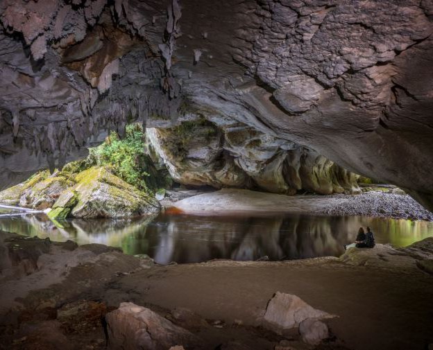
$145 - $190
Oparara Experience
Join us on one of our guided eco tours amongst the pristine rainforest and limestone caves of the unique Oparara Basin. Several tour options available.
Learn more
$80
Lake Brunner Motor Camp
Locally owned and operated classic kiwi camping ground in the heart of Moana with Lake and mountain views. Powered sites, non powered, cabins, tent sites. Walking tracks, fishing, watersports, barista made coffee, clean facilities, pet friendly.
Learn more
$395
Hotel Lake Brunner
Hotel Lake Brunner is situated in Moana, overlooking the picturesque Lake Brunner. Offering a range of accommodation to suit everyone's budgets, apartments to hotel rooms, newly installed wood fired hot tubs, Kingfisher Restaurant and Bar onsite.
Learn more
$890
Lake Brunner Eco Lodge
Sustainable retreat nestled by Lake Brunner. Luxury accommodation amidst lush native bush. Ideal for nature lovers seeking tranquility. Activities include birdwatching, hiking, fishing and kayaking. Experience New Zealand's wilderness in comfort.
Learn more
Ross Goldfields Information & Heritage Centre
Discover Gold Rush Relics and Pan for Gold!
Learn more
225
Ross Beach TOP 10 Holiday Park
Nestled on the edge of the Tasman Sea, we offer a brand new concept in unique, quirky & quality accommodation. You will be surrounded by nature here on the untamed, natural wilderness that is the West Coast of the South Island.
Learn more
32
West Coast Tree Top Walk & Tower Zipline
An exhilarating treetop adventure among temperate rainforest giants. Experience life with birds high in the ancient Rimu and Kamahi tree canopy. Easy access for all to enjoy along a steel platform 20m high and 450m long and a spiral tower 45m high.
Learn more
$45 - $450
Hokitika Scenic Tours
Hokitika Scenic Tours offer specialised informative, sightseeing day and multi day tours and transport to any destination you wish to visit on the West Coast.
Learn more

